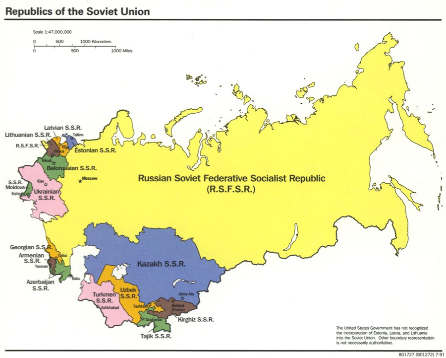
Learning from the Source: Crimea, Ukraine, Russia

Learning from the Source: Crimea, Ukraine, Russia

Overview Students will collaborate to analyze, compare, and contrast newspaper coverage of events in Crimea and Ukraine in the mid-19th century and early 20th century with 2014 media coverage of events involving Crimea, Ukraine and Russia to illuminate the geopolitical history of the region and consider how examining the past shapes perspectives and understanding of…

Guided Primary Source Analysis: States & Territories in Population

Guided Primary Source Analysis: States & Territories in Population

Review the complete document: “Statistical atlas of the United States, based upon the results of the eleventh census” H/T to educator extraordinaire, Cheryl Davis, aka @digitalteacher Which state had the biggest population growth according to this chart? Which region (Northeast, Southeast, Midwest, Northwest, Southwest) had the biggest population gains during these 100 years? What other trend(s) can you…

Primary Source Learning: The Places You’ll Go with Maps

Primary Source Learning: The Places You’ll Go with Maps

The Library of Congress has custody of the largest and most comprehensive cartographic collection in the world and there are so many places you can visit with the Library of Congress’ fabulous digitized map collections. Take a look at the wide variety of maps you can explore in incredible detail and discover engaging primary source…

Today in History: Gilbert Grosvenor & National Geographic

Today in History: Gilbert Grosvenor & National Geographic

Today in History–October 28–the Library of Congress features editor and president of the National Geographic Society, Gilbert Hovey Grosvenor, born on this date in 1875. Just 9 years after immigrating from Turkey to the United States, Grosvenor began working as an assistant editor at National Geographic upon the recommendation of family friend Alexander Graham Bell. Just four years…

Guided Primary Source Analysis: Nicknames of the States

Guided Primary Source Analysis: Nicknames of the States

Which states/territories were not given nicknames? How many states are represented on this? Are there any U.S. states not found on this map? How much would it have cost for you to buy this map in 1884? Why is there an image of one or more pigs on every state? Use these state primary source collections to find out more about one…

Guided Primary Source Analysis: European Immigration

Guided Primary Source Analysis: European Immigration

According to the map, to which country in Europe are most legal immigrants going? From which countries are they coming? How do you know? What three steps were many West European countries taking in response to rising immigration numbers in 1992? What can you find out about current immigration to West European countries? What other observations,…

Guided Primary Source Analysis: Robertson’s Geographic-Historical Series

Guided Primary Source Analysis: Robertson’s Geographic-Historical Series

Who do you think is pictured on the cover of this atlas? Why do you think that? How many years does this atlas cover? Review the list of pages below and choose one title to investigate further. Click the image above to access the digital pages. What did you discover about the topic and time…

Guided Primary Source Analysis: American Expeditionary Force map

Guided Primary Source Analysis: American Expeditionary Force map

The Americans who participated in the liberation of France were shocked by the devastation and the suffering of French civilians who had lost their homes, their livelihood, and their lives during the war. The compassion of the soldiers of the American Expeditionary Forces for the French people generated many popular songs such as “The Tale…

Guided Primary Source Analysis: Indian Timothy Memorial Bridge

Guided Primary Source Analysis: Indian Timothy Memorial Bridge

The caption lists the date of creation of this photo to be 1993. Do you think the bridge was built around the same time as the photo was taken? Why or why not? Look carefully at details in the photograph and the bibliographic record. What purpose do you think this bridge serves? Can you find this…

Featured Source: Night lights

Featured Source: Night lights

Notes – “The National Ocean and Atmospheric Administration’s National Geophysical Data Center and the Defense Meteorological Satellite Program’s Operational Linescan System provided data to NASA Goddard Space Flight Center and Bowie State University in order to render this image of global urban lights.”–On verso. – Includes lesson plan outlines, ill., and 11 maps on verso….

Today in History: Siege of Fort Meigs

Today in History: Siege of Fort Meigs

Today in History–May 9–the Library of Congress features the siege of Fort Meigs by Shawnee military leader Tecumseh and British general Henry A. Proctor on this day in 1813.  But the invaders were unsuccessful as General William Henry Harrison held onto the fort that he had ordered built on the Maumee River above Toledo, Ohio. Learn more by visiting the Today in History section, then click…

Guided Primary Source Analysis: Grand Canyon Tourist Map

Guided Primary Source Analysis: Grand Canyon Tourist Map

List the different data you find on this map (view larger image). Conduct research to compare the data from this map from 1977 with current information and statistics. What similarities and differences did you find? Investigate reasons for the change(s) in data; describe your findings. What other observations, reflections or questions does this source inspire? Let…